Severe Storms with Possible Tornadoes Develop Sunday Afternoon into Sunday Night

April can be one of the most violent times of the year for severe weather in our area and this year looks to be no different. The second in a series of disturbances — the first brought storms to the area Friday and Friday night — will be moving in from the Gulf coast states and intercepting two fronts near or over the area.

Both available ingredients and the general setup appear ripe for super cell development — storms that have the ability to rotate and separate their updraft and downdrafts. By the separation, super cells, can live on as hail grows larger and spin organizes within them.
If you were in the plain states or even in the south and you were looking for an area where tornadoes may develop, you would normally look for the warmest, most unstable part of the air mass ahead of a storm system, then look to see if the area also happens to include lots of wind shear (or vice versa).
And while it is true, you do need wind shear (winds that change direction and speed with height) and unstable air, in our part of southwest Virginia, a wedge of cool, stable air often precedes a major severe weather outbreak with tornadoes.
Often, it’s because the edge of where the cool air settles has it’s own “spin” already along it, so that any rotating storm that intersects it can quickly grow into a tornadic super cell.

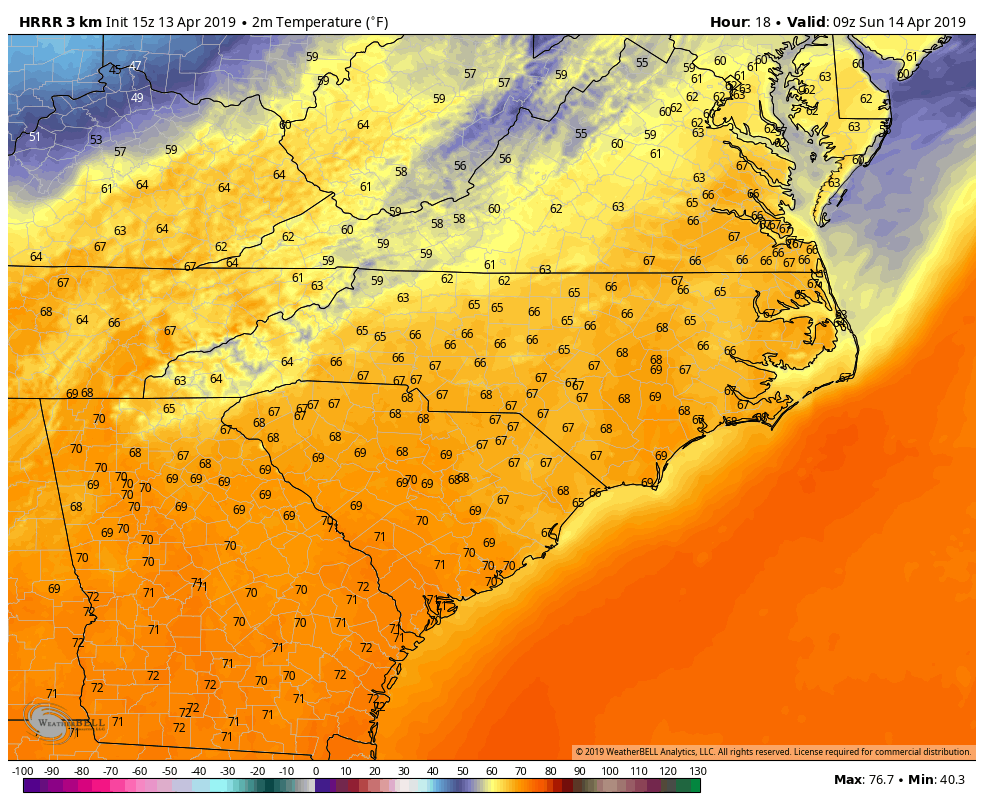
The wedge is in place today behind Friday night’s storm activity. It will likely stay in place through most of Saturday into Saturday night. Again, this is stable air, so within the wedge, storms are possible, but generally not severe.
What happens on Sunday is important. The storm system will be moving into the wedge and pulling it north with time. Storms will begin after 2-3 p.m. and continue along the warm front through 8-10 p.m., possibly later. Right now, there is no way to tell just how far north the warm front (and edge of the wedge) will erode, but as mentioned, the edge of the wedge is where the best chance for tornadoes will be. It will be something I’ll simply have to track in near-real time Sunday.
If you go back and look at all of our recent major tornado events in our area, you will find that the wedge was likely present and played a major role in the tornado’s formation.
Storms may also drop large hail, dangerous lightning, very heavy rain, and produce damaging straight-line winds as well Sunday ahead of a cold front to the west. That front won’t clear the area until after midnight Sunday night. Tornadoes are also possible along it, as well.
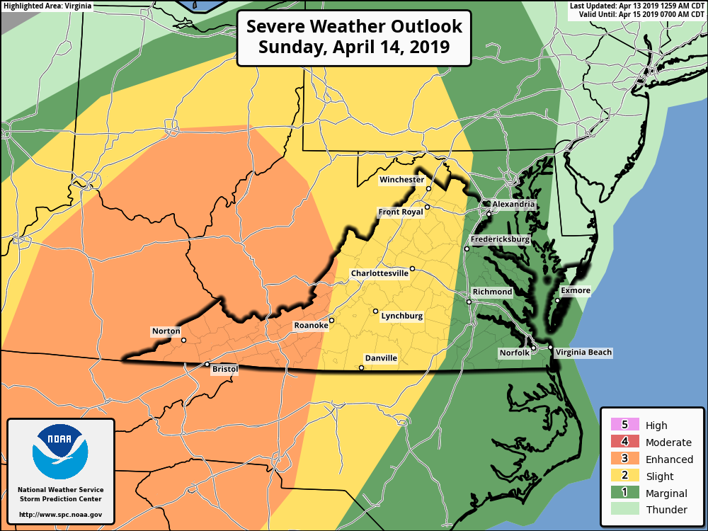
The Storm Prediction Center has most of our area in either a “Slight” risk of severe weather Sunday, but has the New River Valley in an “Enhanced” risk of severe weather. Don’t get too caught up on zones and exact risk areas. Just know it’s a dangerous situation. Many times, the storm outlooks apply not to how severe the storms will be, but the NUMBER of severe storms within the area. Usually, it’s a combination of both.
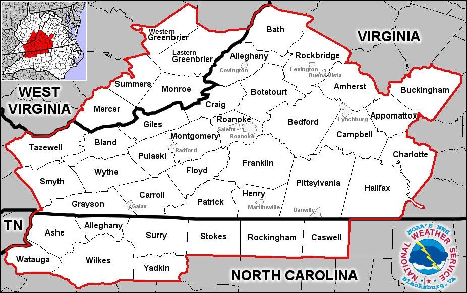
Now is a good time to know where you need to be Sunday and Sunday night if a Tornado WARNING is issued for your area. Do you know what county you live in? If not, google it and find out. It’s not hard. Below is a map to help you…

Know the difference between a watch and a warning. A watch means conditions are coming together. A WARNING means it’s time to act. I posted a model map yesterday and some people thought the *post itself* was a warning! Warnings come from the National Weather Service and will be labeled as such.
When a Tornado Warning is issued for your area, get to the lowest level of a sturdy shelter away from windows. Don’t bother opening windows, the tornado will do that for you. Head into a basement if you have one, under the stairs, a table, or a work bench… put a helmet on if you have one, and cover yourself with blankets or a mattress if you can. Some folks do this in a bathtub, which is fine, UNLESS you live in a mobile home. Even a bathroom in a mobile home is NOT SAFE. You should plan ahead by calling a friend, neighbor, or family member (but somewhere you can get to fast) and make arrangements to head there once a WATCH is issued. That way, when a WARNING comes out, you’ll already be in a sturdy shelter and you can take it from there. If outside, lying in a ditch is safer than being in a mobile home or riding in a car or truck.
There is no guarantee that anyone will see a tornado Sunday or Sunday, and even if we do see one or two, that’s only a very small percentage of the area. Still, this system has the ingredients to provide what I always look for when making these forecasts. Stay calm and take it seriously, and your chances of survival go up greatly.
I’ll have more updates into the day Sunday. Stay weather-aware! Have multiple ways to get warnings.
